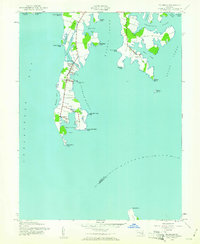
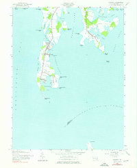
1942 Map of Tilghman
USGS Topo · Published 1961About this map
Tilghman Island dominates this wartime survey, situated at the confluence of the Chesapeake Bay and the Choptank River. The map reveals a specialized maritime landscape where the settlement of Tilghman serves as the hub, connected to the mainland by a crossing at Knapps Narrows. To the south, the communities of Avalon and Fairbank are established along the spine of the island, leading toward the terminal Blackwalnut Point. The intricate coastline is defined by numerous sheltered inlets like Pawpaw Cove and Blackwalnut Cove, which support the local waterman economy evidenced by the Tilghman Island Landing and the protected waters of Dogwood Harbor. Across Harris Creek to the east, the village of Neavitt occupies a peninsula between Balls Creek and Leadenham Creek, illustrating the era's reliance on tidal waterways for transport and industry.
Find a feature on this map
40 named features on this map. Tap any name to fly to it.
Don’t see what you’re looking for? This feature index may not catch every label — zoom into the map to look around manually.
Map Details
Editions of this 1942 Tilghman Map
Other maps of this area

1892 · Annapolis
USGS Topo · 1:62,500

1893 · Sharps Island
USGS Topo · 1:62,500

1898 · Choptank
USGS Topo · 1:125,000

1904 · St. Michaels
USGS Topo · 1:62,500

1904 · Annapolis
USGS Topo · 1:62,500

1904 · Sharps Island
USGS Topo · 1:62,500

1904 · Oxford
USGS Topo · 1:62,500

1908 · Choptank
USGS Topo · 1:125,000

1942 · Tilghman
USGS Topo · 1:31,680

1942 · Oxford
USGS Topo · 1:31,680