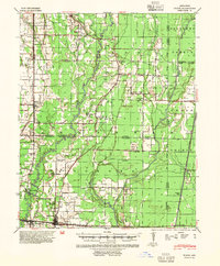
1940 Map of Tilton
USGS Topo · Published 1954About this map
McCrory and Patterson anchor the southern edge of this 1940 survey, a landscape defined by the drainage networks of the Cache River and Bayou De View. The region is a dense grid of rural life and agricultural engineering, marked by an extensive system of man-made waterways like Locust Ditch and Cypress Ditch. For genealogists, the map is particularly rich in family and community landmarks, including several schools like the Blacksville Sch and Pumpkin Bend Sch, alongside numerous church-cemetery sites such as Fakes Chapel Ch & Cem. The presence of the Marianna Lbr Co Abandoned railroad grade and the Missouri Pacific line through Weldon and Tupelo reveals the importance of the timber and transport industries in early twentieth-century Northeast Arkansas.
Find a feature on this map
70 named features on this map. Tap any name to fly to it.
Don’t see what you’re looking for? This feature index may not catch every label — zoom into the map to look around manually.
Map Details
Editions of this 1940 Tilton Map
2 editions found
Other maps of this area

1935 · Newport
USGS Topo · 1:62,500

1935 · Augusta
USGS Topo · 1:62,500

1935 · Tuckerman
USGS Topo · 1:62,500

1935 · Gregory
USGS Topo · 1:62,500

1939 · Vanndale
USGS Topo · 1:62,500

1939 · Weiner
USGS Topo · 1:62,500

1939 · Wynne
USGS Topo · 1:62,500

1939 · Hunter
USGS Topo · 1:62,500

1940 · Tilton
USGS Topo · 1:62,500

1953 · Memphis
USGS Topo · 1:250,000