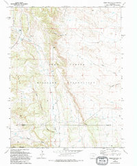
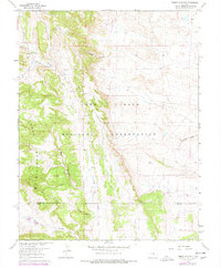
1961 Map of Timber Mountain
USGS Topo · Published 1994About this map
The Fort Carson Military Reservation dominates this 1994 update of a 1961 survey, where the training grounds meet the rising terrain of the Front Range. The landscape is defined by its drainage patterns and canyons, with Timber Mountain and Booth Mountain standing as prominent landmarks on the western edge of the quadrangle. Several significant waterways, including Turkey Creek and Sand Creek, cut through the reservation, while seasonal features like Young Hollow and Crooked Canyon mark the complex topography. Along the southern boundary, the map delineates the divide between El Paso and Pueblo counties. This map provides clear documentation of the military land use and water management structures like Duck Pond and the central Reservoir during the late twentieth century, showing the transition from the plains into the foothills.
Find a feature on this map
16 named features on this map. Tap any name to fly to it.
Don’t see what you’re looking for? This feature index may not catch every label — zoom into the map to look around manually.
Map Details
Editions of this 1961 Timber Mountain Map
6 editions found

Other maps of this area

1891 · Pueblo
USGS Topo · 1:125,000

1893 · Colorado Springs
USGS Topo · 1:125,000

1894 · Pueblo
USGS Topo · 1:125,000

1896 · Pueblo
USGS Topo · 1:125,000

1897 · Pueblo
USGS Topo · 1:125,000

1909 · Colorado Springs
USGS Topo · 1:125,000

1942 · Colorado Springs
USGS Topo · 1:125,000

1948 · Mount Big Chief
USGS Topo · 1:24,000

1948 · Mount Pittsburg
USGS Topo · 1:24,000

1948 · Timber Mountain
USGS Topo · 1:24,000