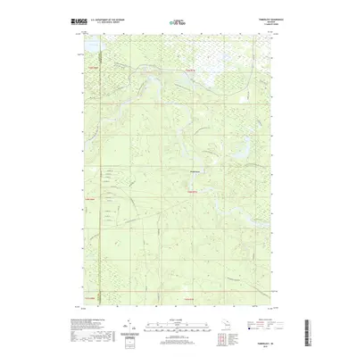
2019 Map of Timberlost
USGS Topo · Published 2019About this map
The Tahquamenon River winds through this heavily forested reach of the Upper Peninsula, creating a landscape defined by its glacial hydrology and isolated settlements like Timberlost. The topography is dominated by numerous small water bodies including the Water Tank Lakes, Cabin Lake, and Camp Ten Lakes, which are interspersed among wetlands and drainage systems such as Schouts Cr and Popps Cr. This area, situated along the border of Luce and Chippewa counties, shows a network of resource-management and access roads, some following older transportation corridors like the Culhane Grade Rd. The presence of Lower Falls on the river remains a central landmark in a region characterized by extensive timberlands and seasonal access. To the south, the terrain leads toward Whitehouse Landing Rd, marking a transition between the river's winding course and the flatter northern interior.
Find a feature on this map
50 named features on this map. Tap any name to fly to it.
Don’t see what you’re looking for? This feature index may not catch every label — zoom into the map to look around manually.
Map Details
Editions of this 2019 Timberlost Map
This is the sole edition of this map. No revisions or reprints were ever made.
Other maps of this area

1951 · Shelldrake
USGS Topo · 1:24,000

1951 · Sheephead Lake
USGS Topo · 1:24,000

1951 · Emerson
USGS Topo · 1:24,000

1951 · Piatt Lake
USGS Topo · 1:24,000

1951 · Big Beaver Creek
USGS Topo · 1:24,000

1951 · Timberlost
USGS Topo · 1:24,000

1951 · Eckerman
USGS Topo · 1:62,500

1951 · Shelldrake
USGS Topo · 1:62,500

1954 · Sault Sainte Marie
USGS Topo · 1:250,000

1956 · Sault Sainte Marie
USGS Topo · 1:250,000