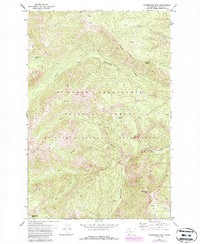
1971 Map of Timberwolf Mtn.
USGS Topo · Published 1987About this map
Mt Baker - Snoqualmie National Forest dominates this high-elevation landscape, where the headwaters of the North Fork Rattlesnake Creek carve deep drainages through the Cascade range. The 1971 survey, updated with 1980s revisions, highlights the protected status of the William O Douglas Wilderness, a region defined by its lack of roads and emphasis on preservation. Dominant peaks like Timberwolf Mtn and Nelson Butte serve as primary landmarks for orientation, with the Timberwolf Lookout providing a key vantage point over the complex terrain. The map records a series of named water sources and alpine features, including Richmond Lake and Clover Spring, which indicate the critical water-shedding nature of this area. The presence of the Wilderness Boundary and designated trails like Lookout underscores the transition from managed forest land to strictly preserved wilderness at the height of the 20th-century conservation era.
Find a feature on this map
20 named features on this map. Tap any name to fly to it.
Don’t see what you’re looking for? This feature index may not catch every label — zoom into the map to look around manually.
Map Details
Editions of this 1971 Timberwolf Mtn. Map
3 editions found
Other maps of this area

1902 · Mount Aix
USGS Topo · 1:125,000

1904 · Mt Aix
USGS Topo · 1:125,000

1950 · Yakima
USGS Topo · 1:250,000

1958 · Yakima
USGS Topo · 1:250,000

1961 · Yakima
USGS Topo · 1:250,000

1962 · Bumping Lake
USGS Topo · 1:62,500

1962 · White Pass
USGS Topo · 1:62,500

1967 · Rimrock Lake
USGS Topo · 1:24,000

1967 · Tieton Basin
USGS Topo · 1:24,000
1971 · Cliffdell
USGS Topo · 1:24,000