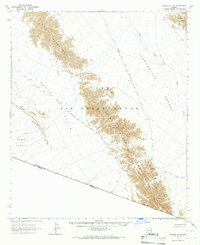
1965 Map of Tinajas Altas
USGS Topo · Published 1966About this map
The historic Camino del Diablo cuts through the arid Yuma County landscape, marking an approximate route that has long served as a vital passage through this section of the Yuma Desert. This 1960s survey captures a stark borderland where the Tinajas Altas Mountains and Gila Mountains rise sharply above the Davis Plain. The map details the remote geography of the Luke Air Force Range, an area defined by rugged relief and vital water points like the Tinajas Altas rock tanks and Raven Butte Tank. Near the northern edge of the quadrangle, evidence of desert industry is preserved at the Smitty Mine within the Copper Mts. Tracing the international boundary between the United States and Mexico, the sheet illustrates the physical isolation of landmarks such as Cipriano Pass and Tinajas Altas Pass, where the arid terrain dictated the paths of early travelers and prospectors.
Find a feature on this map
20 named features on this map. Tap any name to fly to it.
Don’t see what you’re looking for? This feature index may not catch every label — zoom into the map to look around manually.
Map Details
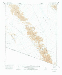
Editions of this 1965 Tinajas Altas Map
2 editions found
Other maps of this area

1926 · Fortuna
USGS Topo · 1:62,500

1926 · Wellton
USGS Topo · 1:62,500

1926 · Mohawk
USGS Topo · 1:62,500

1928 · Mohawk
USGS Topo · 1:62,500

1929 · Fortuna
USGS Topo · 1:62,500

1929 · Wellton
USGS Topo · 1:62,500

1942 · Yuma
USGS Topo · 1:250,000

1953 · Ajo
USGS Topo · 1:250,000

1954 · El Centro
USGS Topo · 1:250,000

1955 · El Centro
USGS Topo · 1:250,000