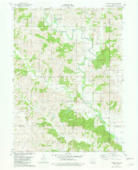
1981 Map of Tingley NE
USGS Topo · Published 1981About this map
The Thompson River and its many tributaries carve a rolling agricultural landscape at the junction of four Iowa counties: Union, Clarke, Ringgold, and Decatur. This 1981 survey by the U.S. Geological Survey and the Iowa Geological Survey shows a deeply rural region organized around its waterways, with Fourmile Creek, Sevenmile Creek, and Twelvemile Creek providing the primary drainage. The map provides a detailed look at rural infrastructure in the late 1970s, featuring localized landmarks such as Spring Valley Lake and small country churches including Pleasant Valley Ch and Oak Hill Ch. Genealogists and local historians can pinpoint family burial sites at Otterbein Cem and Cornwall Cem, while industry is represented by scattered Quarry operations. The division of the land into townships like Jones, Thompson, and Doyle reflects the enduring survey grid that shaped southern Iowa settlement.
Find a feature on this map
22 named features on this map. Tap any name to fly to it.
Don’t see what you’re looking for? This feature index may not catch every label — zoom into the map to look around manually.
Map Details
Editions of this 1981 Tingley NE Map
This is the sole edition of this map. No revisions or reprints were ever made.
Other maps of this area

1951 · Osceola
USGS Topo · 1:62,500

1951 · Afton
USGS Topo · 1:62,500

1954 · Centerville
USGS Topo · 1:250,000

1954 · Omaha
USGS Topo · 1:250,000

1954 · Des Moines
USGS Topo · 1:250,000

1955 · Nebraska City
USGS Topo · 1:250,000

1956 · Des Moines
USGS Topo · 1:250,000

1957 · Des Moines
USGS Topo · 1:250,000

1957 · Nebraska City
USGS Topo · 1:250,000

1957 · Omaha
USGS Topo · 1:250,000