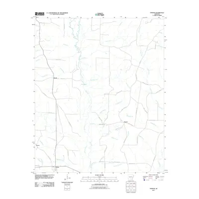
2011 Map of Tinsman
USGS Topo · Published 2011About this map
Tinsman and its surrounding rural timber and wetlands are the focus of this 2011 study in southern Arkansas. The landscape is defined by the winding course of Moro Creek, which meanders south through a complex network of tributaries including Rough Branch and White Oak Creek. The distribution of small settlements like Ellisville, Wagnon, and Watson shows a settlement pattern dictated by the low-lying drainage basins, where high ground is sparse. Local history is anchored at the Williams Cemetery, situated near the center of the quadrangle between Parr Branch and Lavender Branch. The eastern edge of the survey transitions into the Irish Bill Creek drainage, while the southern boundary follows the path of Blue Springs Branch near Blue Springs. The extensive naming of small waterways like Douglas Branch and Watson Creek reflects the vital role of water management and topography in this part of Calhoun County.
Find a feature on this map
60 named features on this map. Tap any name to fly to it.
Don’t see what you’re looking for? This feature index may not catch every label — zoom into the map to look around manually.
Map Details
Editions of this 2011 Tinsman Map
This is the sole edition of this map. No revisions or reprints were ever made.
Other maps of this area

1953 · El Dorado
USGS Topo · 1:250,000

1957 · El Dorado
USGS Topo · 1:250,000

1958 · El Dorado
USGS Topo · 1:250,000

1960 · El Dorado
USGS Topo · 1:250,000

1966 · Kingsland
USGS Topo · 1:24,000

1966 · Fordyce
USGS Topo · 1:24,000

1970 · New Edinburg
USGS Topo · 1:24,000
1973 · Hampton
USGS Topo · 1:24,000
1973 · Mc Kinney
USGS Topo · 1:24,000
1973 · Farmville
USGS Topo · 1:24,000