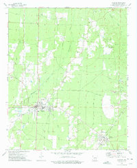
1973 Map of Hampton
USGS Topo · Published 1975About this map
The county seat of Hampton serves as the central hub of this 1970s landscape, where the local economy and infrastructure are defined by a network of timberlands, pipelines, and numerous extraction sites. Numerous Gravel Pits are scattered across the terrain, particularly near the banks of Champagnolle Creek and Taylor Creek. This period shows the community established with civic landmarks like Ham Moses Park and several country churches that anchored rural life, including Union Ch and Campground Ch. To the southeast, the town of Harrell sits along the Chicago Rock Island and Pacific railroad, illustrating the importance of rail transport for moving local resources. Genealogists will find several family and community landmarks, such as Macedonia Cem, Means Cem, and Earnest Cem, which provide specific points of reference for the families settled between Hurricane Creek and Blann Creek.
Find a feature on this map
23 named features on this map. Tap any name to fly to it.
Don’t see what you’re looking for? This feature index may not catch every label — zoom into the map to look around manually.
Map Details
Editions of this 1973 Hampton Map
2 editions found
Other maps of this area

1903 · Camden
USGS Topo · 1:125,000

1934 · Moro Bay
USGS Topo · 1:62,500

1938 · Moro Bay
USGS Topo · 1:62,500

1939 · Moro Bay
USGS Topo · 1:62,500

1953 · El Dorado
USGS Topo · 1:250,000

1957 · El Dorado
USGS Topo · 1:250,000

1958 · El Dorado
USGS Topo · 1:250,000

1960 · El Dorado
USGS Topo · 1:250,000

1962 · Smackover NE
USGS Topo · 1:24,000

1964 · Smackover
USGS Topo · 1:62,500