
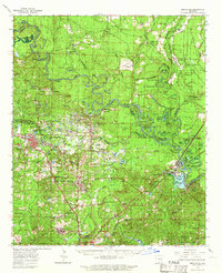
1964 Map of Smackover
USGS Topo · Published 1964About this map
The Ouachita River winds through this 1960s landscape, defining the boundary between Ouachita, Calhoun, and Union counties. This era reveals a region dominated by the petroleum industry, evidenced by the extensive Smackover Oil & Gas Field and several others like the Hampton Oil Field and Champagnolle Landing Oil Field. Settlements such as Smackover, Norphlet, and Standard-Umstead serve as hubs for this industrial activity, while the Missouri Pacific railroad provides the essential overland connection for the region's resources.
Find a feature on this map
106 named features on this map. Tap any name to fly to it.
Don’t see what you’re looking for? This feature index may not catch every label — zoom into the map to look around manually.
Map Details
Editions of this 1964 Smackover Map
2 editions found
Other maps of this area

1903 · Camden
USGS Topo · 1:125,000

1927 · El Dorado
USGS Topo · 1:62,500

1930 · El Dorado
USGS Topo · 1:62,500

1933 · Strong
USGS Topo · 1:62,500

1934 · Moro Bay
USGS Topo · 1:62,500

1937 · Strong
USGS Topo · 1:62,500

1938 · Moro Bay
USGS Topo · 1:62,500

1939 · Moro Bay
USGS Topo · 1:62,500

1939 · Strong
USGS Topo · 1:62,500

1951 · Camden
USGS Topo · 1:24,000