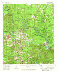
1964 Map of Smackover
USGS Topo · Published 1966About this map
The Ouachita River meanders through a landscape defined by its complex hydrology and the industrial footprint of the Arkansas oil boom. This survey reveals a dense network of water features including Black Lake, Little Bay Lake, and unique brake formations like Cabeen Brake and Signboard Brake. The human geography is centered on the Smackover Oil & Gas Field and the Hampton Oil Field, showing the infrastructure of energy extraction with numerous pipelines and a Tank Farm south of Norphlet.
Find a feature on this map
83 named features on this map. Tap any name to fly to it.
Don’t see what you’re looking for? This feature index may not catch every label — zoom into the map to look around manually.
Map Details
Editions of this 1964 Smackover Map
2 editions found

Other maps of this area

1903 · Camden
USGS Topo · 1:125,000

1927 · El Dorado
USGS Topo · 1:62,500

1930 · El Dorado
USGS Topo · 1:62,500

1933 · Strong
USGS Topo · 1:62,500

1934 · Moro Bay
USGS Topo · 1:62,500

1937 · Strong
USGS Topo · 1:62,500

1938 · Moro Bay
USGS Topo · 1:62,500

1939 · Moro Bay
USGS Topo · 1:62,500

1939 · Strong
USGS Topo · 1:62,500

1951 · Camden
USGS Topo · 1:24,000