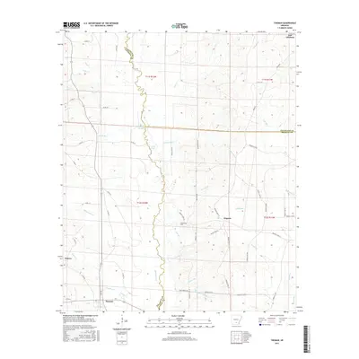
2017 Map of Tinsman
USGS Topo · Published 2017About this map
Moro Cr winds southward through this 2017 study, defining the winding boundary between Calhoun, Cleveland, and Bradley Counties. The settlement of Tinsman serves as a primary local hub in the south, while New Edinburg occupies the northeastern corner, illustrating the persistent rural settlement patterns of south-central Arkansas. The landscape is deeply etched by a dense network of tributaries including Whitewater Cr, Watson Cr, and Fritz Cr, which drain into the larger bottomlands. Genealogists and local historians can locate specific landmarks such as the Williams Cem near Wagnon, alongside numerous county and Bradley roads that trace the timbered terrain. The presence of features like Scott Water and Big Slough highlights the hydrologic character of the region, where water defines both the property lines and the historical development of these three adjoining counties.
Find a feature on this map
71 named features on this map. Tap any name to fly to it.
Don’t see what you’re looking for? This feature index may not catch every label — zoom into the map to look around manually.
Map Details
Editions of this 2017 Tinsman Map
This is the sole edition of this map. No revisions or reprints were ever made.
Other maps of this area

1953 · El Dorado
USGS Topo · 1:250,000
1957 · El Dorado
USGS Topo · 1:250,000
1958 · El Dorado
USGS Topo · 1:250,000
1960 · El Dorado
USGS Topo · 1:250,000
1966 · Kingsland
USGS Topo · 1:24,000
1966 · Fordyce
USGS Topo · 1:24,000
1970 · New Edinburg
USGS Topo · 1:24,000
1973 · Hampton
USGS Topo · 1:24,000
1973 · Mc Kinney
USGS Topo · 1:24,000
1973 · Farmville
USGS Topo · 1:24,000