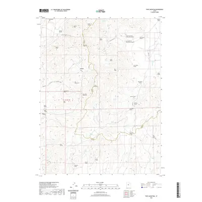
2020 Map of Tintic Mountain
USGS Topo · Published 2020About this map
Tintic Mountain and the East Tintic Mountains dominate this 2020 landscape, straddling the boundary between Juab and Utah Counties. The settlement at Dennis sits at the intersection of several local routes, including Dennis Rd and the path toward the Ockleberry Corrals. The complex topography is defined by high-altitude peaks such as Rattlesnake Peak, Volcano Ridge, and Buckhorn Mtn, which transition into the drainage systems of Goshen Valley and Little Dog Valley. This survey captures a modern view of a region historically defined by its mineral wealth and rugged livestock range, visible through the network of named springs like Keystone Springs and Riley Springs that sustain life in the canyons. Notable landforms like The Devils Steps and The Headwaters illustrate the intricate erosion patterns of the Great Basin's eastern edge.
Find a feature on this map
60 named features on this map. Tap any name to fly to it.
Don’t see what you’re looking for? This feature index may not catch every label — zoom into the map to look around manually.
Map Details
Editions of this 2020 Tintic Mountain Map
This is the sole edition of this map. No revisions or reprints were ever made.
Other maps of this area
1885 · Manti
USGS Topo · 1:250,000
1885 · Sevier Desert
USGS Topo · 1:250,000
1895 · Manti
USGS Topo · 1:250,000
1949 · Eureka
USGS Topo · 1:24,000
1951 · Santaquin
USGS Topo · 1:62,500
1951 · Nephi
USGS Topo · 1:62,500
1953 · Delta
USGS Topo · 1:250,000
1954 · Mc Intyre
USGS Topo · 1:24,000
1954 · Tintic Mountain
USGS Topo · 1:24,000
1954 · Tintic Junction
USGS Topo · 1:24,000