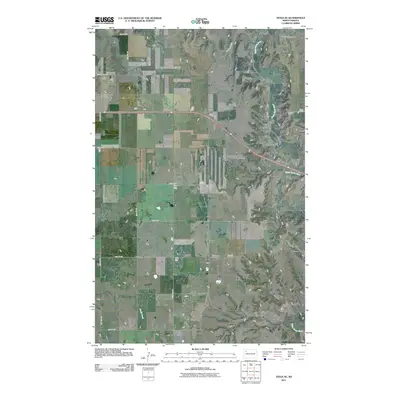
2011 Map of Tioga SE
USGS Topo · Published 2011About this map
The White Earth River meanders across this Mountrail County landscape, defining the topography of the southeastern corner of the Tioga region. This high-plains environment is punctuated by a rigid grid of rural infrastructure, where routes like 66th St NW and 102nd Ave NW intersect the natural drainage patterns of Alkali Creek. The map documents a quiet, enduring rural community where local genealogy is anchored by the Kristiansand Cemetery and the White Earth Cemetery. These landmarks, along with the alignment of County Hwy 23, reveal the spatial organization of North Dakota ranching and farming lands in the early 21st century before modern development significantly altered the traditional township and range structure.
Find a feature on this map
17 named features on this map. Tap any name to fly to it.
Don’t see what you’re looking for? This feature index may not catch every label — zoom into the map to look around manually.
Map Details
Editions of this 2011 Tioga SE Map
This is the sole edition of this map. No revisions or reprints were ever made.
Other maps of this area

1953 · Williston
USGS Topo · 1:250,000

1957 · Williston
USGS Topo · 1:250,000

1965 · Charlson NE
USGS Topo · 1:24,000

1965 · Charlson NW
USGS Topo · 1:24,000

1969 · Ross NW
USGS Topo · 1:24,000

1969 · White Earth
USGS Topo · 1:24,000

1979 · Tioga SE
USGS Topo · 1:24,000
1979 · Tioga SW
USGS Topo · 1:24,000
1979 · Tioga
USGS Topo · 1:24,000

1981 · Manitou
USGS Topo · 1:24,000