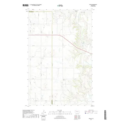
2017 Map of Tioga SE
USGS Topo · Published 2017About this map
The White Earth River meanders through this section of the Williston Basin, marking a landscape defined by its gradual drainage patterns and rural infrastructure. The map highlights several points of historical and genealogical significance, including the White Earth Cem, Saint Francis Catholic Cem, and Kristiansand Cem, which serve as quiet landmarks for the families who settled this prairie. A grid of section roads like 66th St NW and 100th Rd NW bisects the terrain, while Co Hwy 2 cuts diagonally across the northern townships. In the southwest, the waters of Alkali Cr contribute to the drainage of the rolling plains, illustrating the hydrologic character of the region before it meets larger tributaries.
Find a feature on this map
32 named features on this map. Tap any name to fly to it.
Don’t see what you’re looking for? This feature index may not catch every label — zoom into the map to look around manually.
Map Details
Editions of this 2017 Tioga SE Map
This is the sole edition of this map. No revisions or reprints were ever made.
Other maps of this area

1953 · Williston
USGS Topo · 1:250,000

1957 · Williston
USGS Topo · 1:250,000

1965 · Charlson NE
USGS Topo · 1:24,000

1965 · Charlson NW
USGS Topo · 1:24,000

1969 · Ross NW
USGS Topo · 1:24,000

1969 · White Earth
USGS Topo · 1:24,000

1979 · Tioga SE
USGS Topo · 1:24,000
1979 · Tioga SW
USGS Topo · 1:24,000
1979 · Tioga
USGS Topo · 1:24,000

1981 · Manitou
USGS Topo · 1:24,000