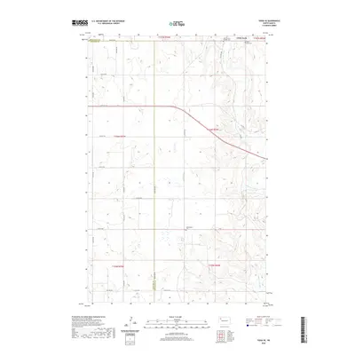
2020 Map of Tioga SE
USGS Topo · Published 2020About this map
White Earth occupies the northeast corner of this West Dakota landscape, situated near the confluence of local drainages and the White Earth River. This 2020 topographic survey illustrates the transition from the high prairie into the dissected valley of the river, which meanders southward toward the Missouri River system. The area's pioneer heritage and community centers are preserved through its sacred sites, including the White Earth Cem, the Saint Francis Catholic Cem, and the more isolated Kristiansand Cem to the south. The western portion of the map is defined by the county line between Mountrail and Williams counties, crossed by a grid of section-line roads like 102nd Ave NW and the diagonal path of Co Hwy 2. Notable water features such as Alkali Cr highlight the characteristic alkaline drainage patterns of the northern plains.
Find a feature on this map
35 named features on this map. Tap any name to fly to it.
Don’t see what you’re looking for? This feature index may not catch every label — zoom into the map to look around manually.
Map Details
Editions of this 2020 Tioga SE Map
This is the sole edition of this map. No revisions or reprints were ever made.
Other maps of this area

1953 · Williston
USGS Topo · 1:250,000

1957 · Williston
USGS Topo · 1:250,000

1965 · Charlson NE
USGS Topo · 1:24,000

1965 · Charlson NW
USGS Topo · 1:24,000

1969 · Ross NW
USGS Topo · 1:24,000

1969 · White Earth
USGS Topo · 1:24,000

1979 · Tioga SE
USGS Topo · 1:24,000
1979 · Tioga SW
USGS Topo · 1:24,000
1979 · Tioga
USGS Topo · 1:24,000

1981 · Manitou
USGS Topo · 1:24,000