
1964 Map of Tipton
USGS Topo · Published 1965About this map
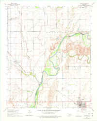
The North Fork Red River snakes through the heart of this mid-1960s landscape, serving as the natural boundary between Jackson and Tillman counties. The town of Tipton anchors the southeastern corner, where a grid of streets meets the Missouri Kansas Texas railroad line. This rail corridor was vital for the local economy, passing through the smaller settlement of Humphreys and tracing the edge of the Boucher Oil Field. Agricultural infrastructure is prominent throughout the quadrangle, evidenced by the Ozark Canal in the north and the presence of a local Orphanage near Tipton. The terrain shifts from the river bottomlands to the higher ground of the Hunter and Headrick townships, with Otter Creek and Sinking Creek providing secondary drainage for the surrounding prairie.
Find a feature on this map
18 named features on this map. Tap any name to fly to it.
Don’t see what you’re looking for? This feature index may not catch every label — zoom into the map to look around manually.
Map Details
Editions of this 1964 Tipton Map
2 editions found
Other maps of this area

1955 · Lawton
USGS Topo · 1:250,000

1958 · Frederick
USGS Topo · 1:62,500

1958 · Elmer
USGS Topo · 1:62,500

1963 · Altus SE
USGS Topo · 1:24,000

1964 · Tipton SE
USGS Topo · 1:24,000

1964 · Altus
USGS Topo · 1:24,000

1964 · Headrick
USGS Topo · 1:24,000

1964 · Long Mountain
USGS Topo · 1:24,000

1975 · Elmore City NE
USGS Topo · 1:24,000

1975 · Frederick NE
USGS Topo · 1:24,000