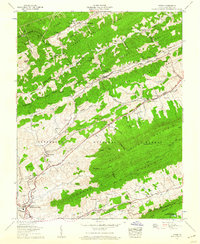
1958 Map of Tiptop
USGS Topo · Published 1960About this map
Wittens Mills and the industrial corridors of Tazewell County are etched into this mid-century landscape, where the Norfolk and Western Railway navigates the narrow valleys between East River Mountain and Stony Ridge. The map documents a complex mountain economy defined by extraction and transit, evidenced by several strip mines and the presence of Prison Camp No 31.
Find a feature on this map
103 named features on this map. Tap any name to fly to it.
Don’t see what you’re looking for? This feature index may not catch every label — zoom into the map to look around manually.
Map Details
Editions of this 1958 Tiptop Map
3 editions found
Other maps of this area

1887 · Pocahontas
USGS Topo · 1:125,000

1891 · Tazewell
USGS Topo · 1:125,000

1891 · Pocahontas
USGS Topo · 1:125,000

1894 · Pocahontas
USGS Topo · 1:125,000

1895 · Tazewell
USGS Topo · 1:125,000

1895 · Pocahontas
USGS Topo · 1:125,000

1897 · Tazewell
USGS Topo · 1:125,000

1909 · Pocahontas Special
USGS Topo · 1:48,000

1911 · Pocahontas Special
USGS Topo · 1:62,500

1912 · Pounding Mill
USGS Topo · 1:62,500