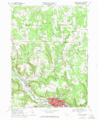
1968 Map of Titusville North
USGS Topo · Published 1971About this map
Titusville stands as the primary urban center in this 1968 landscape, anchoring a region defined by its industrial heritage and rural crossroads. The city's northern reaches feature institutions like the University of Pittsburgh at Titusville and the St Josephs High School, alongside essential community hubs like the Hospital and City Hall. Stretching north from the city, the land rises into the ridges of Rome and Steuben, where numerous Oil Wells dot the terrain, particularly around Vrooman and Rometown. This distribution illustrates the enduring footprint of the Pennsylvania oil boom, with pump jacks and well sites scattered across family-named farms.
Find a feature on this map
63 named features on this map. Tap any name to fly to it.
Don’t see what you’re looking for? This feature index may not catch every label — zoom into the map to look around manually.
Map Details
Editions of this 1968 Titusville North Map
2 editions found
Other maps of this area

1927 · Townville
USGS Topo · 1:48,000

1927 · Titusville
USGS Topo · 1:62,500

1929 · Corry
USGS Topo · 1:48,000

1929 · Union City
USGS Topo · 1:62,500

1932 · Corry
USGS Topo · 1:62,500

1932 · Townville
USGS Topo · 1:62,500

1932 · Union City
USGS Topo · 1:62,500

1933 · Titusville
USGS Topo · 1:62,500

1945 · Townville
USGS Topo · 1:62,500

1957 · Warren
USGS Topo · 1:250,000