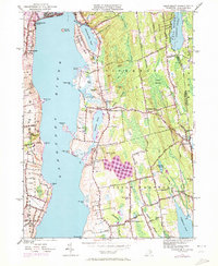
1949 Map of Tiverton
USGS Topo · Published 1972About this map
The Sakonnet River dominates the western edge of this 1949 survey, defining a coastline of marshy points and inlets like Fogland Pt and Sapowet Pt. Moving inland, the landscape of eastern Rhode Island transitions from the tidal waters of Nannaquaket Pond and Nonquit Pond to the interior wetlands of the Great Swamp. Local life in the mid-century period is anchored by small villages and rural crossroads, including Tiverton Four Corners and Adamsville, where historic structures such as Old Stone Ch and Grays Mill appear alongside family-named landmarks like Richmond Hill and Wilcox Hill. The map also documents modern shifts in the terrain, most notably the purple-shaded revisions indicating the establishment of the Harold E Watson Reservoir and newer residential developments near Portsmouth Park. This layer of 1970 photorevisions provides a clear view of how the area's agricultural and coastal character began to change in the post-war era.
Find a feature on this map
76 named features on this map. Tap any name to fly to it.
Don’t see what you’re looking for? This feature index may not catch every label — zoom into the map to look around manually.
Map Details
Editions of this 1949 Tiverton Map
4 editions found
Other maps of this area

1885 · Sakonnet
USGS Topo · 1:62,500

1888 · Fall River
USGS Topo · 1:62,500

1888 · Sakonnet
USGS Topo · 1:62,500

1889 · Newport
USGS Topo · 1:62,500

1890 · Narragansett Bay
USGS Topo · 1:62,500

1892 · Narragansett Bay
USGS Topo · 1:62,500

1893 · Sakonnet
USGS Topo · 1:62,500

1893 · Fall River
USGS Topo · 1:62,500

1894 · Newport
USGS Topo · 1:62,500

1904 · Newport
USGS Topo · 1:62,500