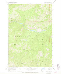
1966 Map of Toboggan Ridge
USGS Topo · Published 1969About this map
Kelly Creek carves a deep path through this interior portion of the Clearwater National Forest, a landscape defined by sharp divides and named high points. Surveyed in the mid-1960s, the terrain is marked by the eponymous Toboggan Ridge and the nearby Toboggan Hill. This area is characterized by its drainage network, where numerous tributaries like Kodiak Creek, Bear Creek, and Cub Creek flow from the surrounding heights toward the main valley. The map reveals a reliance on a primitive transportation network of Pack Trails that navigate the ridges and basins, such as the path through Hanson Meadows. Distinctive landmarks like Kellys Thumb and Kellys Sister serve as navigational anchors within this backcountry, which remains largely untouched by modern road development during this era.
Find a feature on this map
28 named features on this map. Tap any name to fly to it.
Don’t see what you’re looking for? This feature index may not catch every label — zoom into the map to look around manually.
Map Details
Editions of this 1966 Toboggan Ridge Map
2 editions found
Other maps of this area

1911 · Lolo
USGS Topo · 1:250,000

1913 · Lolo
USGS Topo · 1:250,000

1956 · Hamilton
USGS Topo · 1:250,000

1959 · Hamilton
USGS Topo · 1:250,000

1960 · Hamilton
USGS Topo · 1:250,000

1960 · Straight Peak
USGS Topo · 1:62,500

1964 · Hamilton
USGS Topo · 1:250,000

1965 · Osier Ridge
USGS Topo · 1:24,000

1965 · Gorman Hill
USGS Topo · 1:24,000

1965 · Horseshoe Lake
USGS Topo · 1:24,000