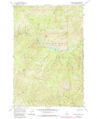
1966 Map of Toboggan Ridge
USGS Topo · Published 1984About this map
Kelly Creek dominates this mid-1960s landscape, winding through a wilderness defined by high summits and deep drainage basins within the Clearwater National Forest. The map captures a moment when travel through this backcountry relied heavily on a network of Pack Trails, connecting remote high points like Toboggan Ridge and Moose Ridge. The presence of Hanson Meadows along the creek bank provides a rare break in the timbered slopes, serving as a landmark for those navigating between Hanson Ridge and the southern Linde Ridge. Named landmarks such as Kellys Thumb and Kellys Sister stand as distinctive visual markers above the numerous tributaries, including Rapid Creek and Bear Creek, illustrating the detailed hydrological mapping required for forest management and backcountry navigation during this era.
Find a feature on this map
28 named features on this map. Tap any name to fly to it.
Don’t see what you’re looking for? This feature index may not catch every label — zoom into the map to look around manually.
Map Details
Editions of this 1966 Toboggan Ridge Map
2 editions found
Other maps of this area

1911 · Lolo
USGS Topo · 1:250,000

1913 · Lolo
USGS Topo · 1:250,000

1956 · Hamilton
USGS Topo · 1:250,000

1959 · Hamilton
USGS Topo · 1:250,000

1960 · Hamilton
USGS Topo · 1:250,000

1960 · Straight Peak
USGS Topo · 1:62,500

1964 · Hamilton
USGS Topo · 1:250,000

1965 · Osier Ridge
USGS Topo · 1:24,000

1965 · Gorman Hill
USGS Topo · 1:24,000

1965 · Horseshoe Lake
USGS Topo · 1:24,000