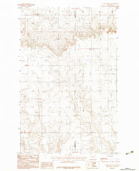
1983 Map of Todd Lakes NE
USGS Topo · Published 1983About this map
The Fort Peck Indian Reservation encompasses this entire portion of northeastern Montana, where the prairie landscape is defined by the winding drainages of the Missouri River watershed. In the northern reaches, Cottonwood Creek cuts through the high plains, while the central and southern portions of the sheet are dominated by the deeply incised valley of the East Fork Wolf Creek. This 1983 provisional survey captures the area as it transitioned from earlier manuscript drawings to modern topographic standards. Human activity is sparse across these sections, marked primarily by a remote Airstrip and the surveyed boundary separating Valley and Roosevelt counties. The map provides a clear record of the section-line roads and unimproved trails that supported the ranching and tribal lands during the late twentieth century.
Find a feature on this map
5 named features on this map. Tap any name to fly to it.
Don’t see what you’re looking for? This feature index may not catch every label — zoom into the map to look around manually.
Map Details
Editions of this 1983 Todd Lakes NE Map
This is the sole edition of this map. No revisions or reprints were ever made.
Other maps of this area

1910 · Todd Lakes
USGS Topo · 1:62,500

1915 · Tule Valley
USGS Topo · 1:62,500

1915 · Todd Lakes
USGS Topo · 1:62,500

1954 · Wolf Point
USGS Topo · 1:250,000

1958 · Wolf Point
USGS Topo · 1:250,000

1973 · Haugens Hill
USGS Topo · 1:24,000

1973 · Peerless 4 SW
USGS Topo · 1:24,000

1973 · Poplar Coulee
USGS Topo · 1:24,000
1983 · Todd Lakes
USGS Topo · 1:24,000
1983 · Tule Valley West
USGS Topo · 1:24,000