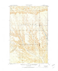
1910 Map of Todd Lakes
USGS Topo · Published 1975About this map
The Fort Peck Indian Reservation dominates this 1910 landscape, a vast area of dissected plateaus and coulees surveyed by the General Land Office. The map illustrates a complex drainage system essential to the high plains, centered on the confluence and divergent branches of Wolf Creek. The intricate braiding of the West Fork, Middle Fork, and East Fork Wolf Creek reveals the natural hydrology of the terrain before later developments. Toward the northwest, Little Porcupine Creek and Cottonwood Creek cut through the rising elevations, while the eponymous Todd Lakes appear as small catchment basins in the southern reaches. This topographic study captures the region as a purely natural and administrative space, defined by its watercourses and the established Boundary Line between Valley and Sheridan counties.
Find a feature on this map
11 named features on this map. Tap any name to fly to it.
Don’t see what you’re looking for? This feature index may not catch every label — zoom into the map to look around manually.
Map Details
Editions of this 1910 Todd Lakes Map
2 editions found
Other maps of this area

1910 · Todd Lakes
USGS Topo · 1:62,500

1915 · Tule Valley
USGS Topo · 1:62,500

1915 · Frazer
USGS Topo · 1:62,500

1915 · Oswego
USGS Topo · 1:62,500

1915 · Todd Lakes
USGS Topo · 1:62,500

1915 · Spring Creek
USGS Topo · 1:62,500

1916 · Wolf Point
USGS Topo · 1:62,500

1954 · Wolf Point
USGS Topo · 1:250,000

1954 · Glasgow
USGS Topo · 1:250,000

1957 · Glasgow
USGS Topo · 1:250,000
Featured Places
- Wolf Point District, MT
- Frazer District, MT
- Oswego District, MT
- Lustre, Oswego District
- Roosevelt County, MT