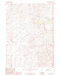
1987 Map of Toe Jam Mountain
USGS Topo · Published 1987About this map
The Tuscarora Mountains dominate this 1987 survey of Elko County, defining a landscape shaped by high-elevation drainage systems and mineral exploration. The rugged central topography is anchored by Toe Jam Mountain and Walker Mountain, which serve as the headwaters for several seasonal and perennial streams including Toe Creek, Jam Creek, and Lewis Creek.
Find a feature on this map
14 named features on this map. Tap any name to fly to it.
Don’t see what you’re looking for? This feature index may not catch every label — zoom into the map to look around manually.
Map Details
Editions of this 1987 Toe Jam Mountain Map
This is the sole edition of this map. No revisions or reprints were ever made.
Other maps of this area

1955 · McDermitt
USGS Topo · 1:250,000

1956 · Mt. Blitzen
USGS Topo · 1:62,500

1959 · McDermitt
USGS Topo · 1:250,000

1965 · Willow Creek Reservoir
USGS Topo · 1:24,000

1970 · Sugarloaf Butte
USGS Topo · 1:24,000
1970 · China Camp
USGS Topo · 1:24,000

1973 · Little Rock Creek
USGS Topo · 1:24,000

1974 · Soldier Cap
USGS Topo · 1:24,000

1982 · Tuscarora
USGS Topo · 1:100,000
1987 · Red Cow Creek
USGS Topo · 1:24,000