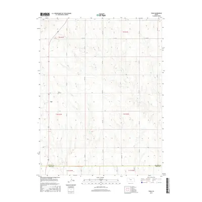
2015 Map of Togo
USGS Topo · Published 2015About this map
Togo sits within a landscape defined by the geometric precision of the Public Land Survey System, located along the southern edge of Graham County. This rural township is characterized by its organized grid of local routes like Co Rd 551 and 270th Ave, which carve through the undulating plains. The drainage patterns of Chalk Cr and Happy Cr provide the primary natural relief to the structured section lines. The presence of Prairie Home Cem north of the settlement serves as a significant marker for genealogical research, anchoring the local history of the families who settled this portion of the High Plains. The map also delineates the border between Graham Co and Trego Co, illustrating the administrative divisions that have shaped the region's development since its early agricultural establishment.
Find a feature on this map
28 named features on this map. Tap any name to fly to it.
Don’t see what you’re looking for? This feature index may not catch every label — zoom into the map to look around manually.
Map Details
Editions of this 2015 Togo Map
This is the sole edition of this map. No revisions or reprints were ever made.
Other maps of this area
1893 · Hill
USGS Topo · 1:125,000
1955 · Beloit
USGS Topo · 1:250,000
1959 · Beloit
USGS Topo · 1:250,000
1962 · Wa Keeney East
USGS Topo · 1:24,000
1963 · Wa Keeney West
USGS Topo · 1:24,000
1963 · Hill City 4 SW
USGS Topo · 1:24,000
1979 · Bogue
USGS Topo · 1:24,000
1979 · Hill City South
USGS Topo · 1:24,000
1979 · Penokee
USGS Topo · 1:24,000
1979 · Hay Hollow
USGS Topo · 1:24,000