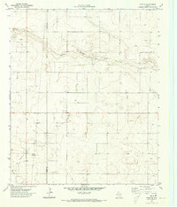
1970 Map of Tokio SE
USGS Topo · Published 1973About this map
The Yoakum Co and Terry Co boundary line runs through this 1970 landscape, marked by a pattern of resource extraction and water management on the High Plains. The most prominent natural feature is Sulphur Springs Draw, which meanders across the northern half of the quadrangle. The map reveals an industrializing rural environment, evidenced by numerous Oil Wells, scattered Drill Holes, and various Gravel Pits. Local infrastructure is anchored by a Pumping Sta and a Substa located along the highway corridors, illustrating how the region's energy and mineral wealth were being actively tapped during this period. The survey's focus on hydrology is clear, with many Wells and a Water Tank noted across the terrain to support both oil operations and ranching in this arid Texas territory.
Find a feature on this map
12 named features on this map. Tap any name to fly to it.
Don’t see what you’re looking for? This feature index may not catch every label — zoom into the map to look around manually.
Map Details
Editions of this 1970 Tokio SE Map
This is the sole edition of this map. No revisions or reprints were ever made.
Other maps of this area

1954 · Hobbs
USGS Topo · 1:250,000

1954 · Brownfield
USGS Topo · 1:250,000

1958 · Brownfield
USGS Topo · 1:250,000

1958 · Hobbs
USGS Topo · 1:250,000

1962 · Brownfield
USGS Topo · 1:250,000

1969 · Gomez
USGS Topo · 1:24,000

1969 · Loop
USGS Topo · 1:24,000

1969 · Wellman
USGS Topo · 1:24,000

1970 · Seagraves
USGS Topo · 1:24,000

1970 · Tokio
USGS Topo · 1:24,000