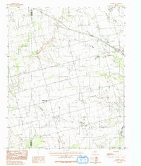
1983 Map of Tolbert
USGS Topo · Published 1992About this map
The Pease River marks the southern boundary of this 1980s Texas landscape, where the rugged terrain of Wilbarger County meets Hardeman County. Centered on the small settlement of Tolbert, the area is defined by a dendritic drainage network of seasonal waterways including Wildcat Creek, Boggy Creek, and Dan Creek. These creeks carve through the plains, creating a complex series of draws and ridges that dictated the placement of local roads and cattle crossings. To the west, the community of Farmers Valley sits near the headwaters of Elizabeth Creek, illustrating the dispersed rural settlement patterns typical of the region during this era. Evidence of modern infrastructure is seen in the prominent Radio Tower and a major Pipeline cutting across the southwestern quadrant, reflecting the integration of industrial utilities into the cattle-ranching landscape. Genealogists may find interest in the isolated Cem located near the town of Tolbert, a small but vital landmark for local family history research.
Find a feature on this map
11 named features on this map. Tap any name to fly to it.
Don’t see what you’re looking for? This feature index may not catch every label — zoom into the map to look around manually.
Map Details
Editions of this 1983 Tolbert Map
2 editions found
Other maps of this area

1955 · Lawton
USGS Topo · 1:250,000

1958 · Vernon
USGS Topo · 1:62,500

1958 · Medicine Mound
USGS Topo · 1:62,500

1958 · Elmer
USGS Topo · 1:62,500

1960 · Quanah
USGS Topo · 1:62,500

1983 · Warrior Hollow
USGS Topo · 1:24,000

1983 · Tolbert
USGS Topo · 1:24,000
1983 · Rayland
USGS Topo · 1:24,000
1983 · Lockett
USGS Topo · 1:24,000
1983 · Vernon
USGS Topo · 1:24,000