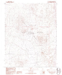
1986 Map of Tolicha Peak NE
USGS Topo · Published 1986About this map
Pahute Mesa dominates this 1980s landscape, providing a high-altitude topographical record of a highly restricted military zone in Nye County. The area is defined by the Nellis Air Force Range, where the natural volcanic tableland is marked by numerous tactical waypoints and specialized nomenclature. These labels, such as Totter, Teeter, El Portal, and Shrimp, likely served as internal navigation or mission-specific points of reference within the restricted airspace. While the terrain is void of traditional civilian towns or post offices, the map is densely populated with specific named Targets and markers like Dudley, Convoy, and Millie. This provisional survey documents the specialized infrastructure and spatial organization required for cold-war era military operations and testing in the Nevada desert.
Find a feature on this map
28 named features on this map. Tap any name to fly to it.
Don’t see what you’re looking for? This feature index may not catch every label — zoom into the map to look around manually.
Map Details
Editions of this 1986 Tolicha Peak NE Map
This is the sole edition of this map. No revisions or reprints were ever made.
Other maps of this area

1908 · Kawich
USGS Topo · 1:250,000

1942 · Tolicha Peak
USGS Topo · 1:125,000

1942 · Cactus Range
USGS Topo · 1:125,000

1952 · Mellan
USGS Topo · 1:62,500

1952 · Cactus Spring
USGS Topo · 1:62,500
1952 · Black Mtn
USGS Topo · 1:62,500

1954 · Goldfield
USGS Topo · 1:250,000

1955 · Goldfield
USGS Topo · 1:250,000

1958 · Goldfield
USGS Topo · 1:250,000

1962 · Goldfield
USGS Topo · 1:250,000