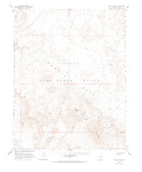
1968 Map of Tolicha Peak
USGS Topo · Published 1970About this map
Nellis Air Force Range dominates this 1968 study, an area mapped in cooperation with the Atomic Energy Commission during a period of intense Cold War activity in the Nevada desert. The high plateau of Pahute Mesa and the volcanic prominence of Tolicha Peak characterize the terrain, which transitions into the low expanse of Sarcobatus Flat to the southwest. This landscape reveals the intersection of mid-century military infrastructure and the region's earlier mining history.
Find a feature on this map
22 named features on this map. Tap any name to fly to it.
Don’t see what you’re looking for? This feature index may not catch every label — zoom into the map to look around manually.
Map Details
Editions of this 1968 Tolicha Peak Map
This is the sole edition of this map. No revisions or reprints were ever made.
Other maps of this area

1908 · Kawich
USGS Topo · 1:250,000

1908 · Lida
USGS Topo · 1:250,000

1913 · Lida
USGS Topo · 1:250,000

1942 · Tolicha Peak
USGS Topo · 1:125,000

1942 · Cactus Range
USGS Topo · 1:125,000

1945 · Goldfield
USGS Topo · 1:125,000

1952 · Mellan
USGS Topo · 1:62,500

1952 · Cactus Spring
USGS Topo · 1:62,500
1952 · Black Mtn
USGS Topo · 1:62,500

1952 · Goldfield
USGS Topo · 1:62,500