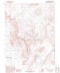
1986 Map of Tolicha Peak SW
USGS Topo · Published 1986About this map
Pahute Mesa dominates the northern horizon of this 1986 survey, situated within the high desert of the Nellis Air Force Range. This high-altitude plateau gives way to the lower reaches of Sarcobatus Flat and the dry bed of Tolicha Wash in the south, illustrating the sharp elevation changes of the Great Basin. The landscape is marked by historical extraction efforts, specifically around the Clarkdale Mine, where a network of Shafts, an Adit, and various Prospects suggest a period of active mineral exploration. The presence of the Restricted Access Area and Coyote Holes highlights the isolated and controlled nature of this territory during the mid-1980s, serving as a record of both industrial mining heritage and modern military land use.
Find a feature on this map
11 named features on this map. Tap any name to fly to it.
Don’t see what you’re looking for? This feature index may not catch every label — zoom into the map to look around manually.
Map Details
Editions of this 1986 Tolicha Peak SW Map
This is the sole edition of this map. No revisions or reprints were ever made.
Other maps of this area

1908 · Kawich
USGS Topo · 1:250,000

1908 · Lida
USGS Topo · 1:250,000

1913 · Lida
USGS Topo · 1:250,000

1942 · Tolicha Peak
USGS Topo · 1:125,000

1954 · Goldfield
USGS Topo · 1:250,000

1955 · Goldfield
USGS Topo · 1:250,000

1958 · Goldfield
USGS Topo · 1:250,000

1962 · Goldfield
USGS Topo · 1:250,000
1966 · Springdale
USGS Topo · 1:62,500
1968 · Tolicha Peak
USGS Topo · 1:62,500