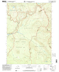
1998 Map of Tolo Mountain
USGS Topo · Published 2000About this map
The Pacific Crest National Scenic Trail winds through high-altitude terrain along the divide between Douglas and Klamath counties, serving as a primary corridor through this protected landscape. This late-twentieth-century revision highlights a region defined by its volcanic geology and primitive water systems, where features like Windigo Pass and Tolo Mountain dominate the eastern ridgelines. The map shows the convergence of the Umpqua National Forest and Deschutes National Forest, with significant portions designated as the Mount Thielsen Wilderness and the Oregon Cascades Recreation Area. Hydrological patterns are marked by isolated basins including Windigo Lakes, Lake Lucile, and Maidu Lake, while the headwaters of the North Umpqua River and Tolo Creek drain the western slopes. A small Cinder Pit near Kelsay Point provides evidence of local material extraction amidst the otherwise preserved wilderness environment.
Find a feature on this map
27 named features on this map. Tap any name to fly to it.
Don’t see what you’re looking for? This feature index may not catch every label — zoom into the map to look around manually.
Map Details
Editions of this 1998 Tolo Mountain Map
This is the sole edition of this map. No revisions or reprints were ever made.
Other maps of this area

1917 · Diamond Lake
USGS Topo · 1:125,000

1935 · Chemult
USGS Topo · 1:96,000

1941 · Chemult
USGS Topo · 1:125,000

1955 · Crescent
USGS Topo · 1:250,000

1956 · Diamond Lake
USGS Topo · 1:62,500

1956 · Summit Lake
USGS Topo · 1:62,500

1957 · Crescent
USGS Topo · 1:250,000

1958 · Crescent
USGS Topo · 1:250,000

1958 · Roseburg
USGS Topo · 1:250,000

1959 · Roseburg
USGS Topo · 1:250,000