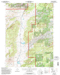
1992 Map of Toltec
USGS Topo · Published 1996About this map
Medicine Bow National Forest dominates the high-altitude landscape of this Wyoming quadrangle, where the historic Old Fort Fetterman Road cuts across the rugged terrain of Albany County. The map documents a sparsely populated but active ranching and resource area during the 1990s, anchored by the Toltec settlement and the Reed Place. Water management is central to the district, evidenced by numerous developed sources such as Soldier Creek Reservoir, Kafko Reservoir, and Eggleston Reservoir. These water bodies, along with the headwaters of the Laramie River, support a landscape marked by peaks like Fortymile Peak and Smith Mountain. The presence of several prospect sites and a Gravel Pit indicates the ongoing intersection of public land management and local extraction, while named landmarks like Reed Pass and Mule Creek Pass suggest the traditional transit corridors through the mountain ranges.
Find a feature on this map
44 named features on this map. Tap any name to fly to it.
Don’t see what you’re looking for? This feature index may not catch every label — zoom into the map to look around manually.
Map Details
Editions of this 1992 Toltec Map
This is the sole edition of this map. No revisions or reprints were ever made.
Other maps of this area

1954 · Torrington
USGS Topo · 1:250,000

1958 · Torrington
USGS Topo · 1:250,000

1964 · Toltec
USGS Topo · 1:24,000

1964 · School Section Mountain
USGS Topo · 1:24,000

1964 · Saddleback Mountain
USGS Topo · 1:24,000

1964 · Windy Peak
USGS Topo · 1:24,000

1964 · Marshall
USGS Topo · 1:24,000
1964 · Warbonnet Peak
USGS Topo · 1:24,000

1968 · Cow Creek Mountain
USGS Topo · 1:24,000

1968 · Cottonwood Creek
USGS Topo · 1:24,000