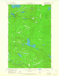
1959 Map of Tom Lake
USGS Topo · Published 1965About this map
The Superior National Forest and Grand Portage State Forest converge in this 1959 survey of northeastern Minnesota's wild northern timberlands. The landscape is dominated by a dense network of glacially formed water bodies, including Devilfish Lake, Esther Lake, and the expansive Tom Lake. The presence of the Devilfish Lookout Tower on a high ridge overlooking the basin highlights the importance of fire surveillance in these heavily wooded sections during the mid-century era.
Find a feature on this map
23 named features on this map. Tap any name to fly to it.
Don’t see what you’re looking for? This feature index may not catch every label — zoom into the map to look around manually.
Map Details
Editions of this 1959 Tom Lake Map
3 editions found
Other maps of this area

1954 · Two Harbors
USGS Topo · 1:250,000

1957 · Two Harbors
USGS Topo · 1:250,000

1957 · Quetico
USGS Topo · 1:250,000

1958 · Two Harbors
USGS Topo · 1:250,000

1958 · Hancock
USGS Topo · 1:250,000

1959 · Northern Light Lake
USGS Topo · 1:24,000

1959 · Pine Lake East
USGS Topo · 1:24,000

1959 · Tom Lake
USGS Topo · 1:24,000

1959 · Pine Lake West
USGS Topo · 1:24,000

1959 · Fort William
USGS Topo · 1:250,000