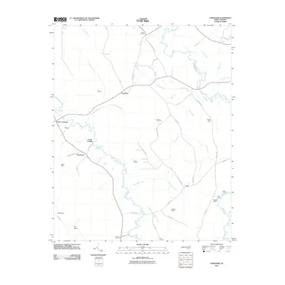
2010 Map of Tomahawk
USGS Topo · Published 2010About this map
Tomahawk and Fowler Landing anchor a rural landscape defined by the sinuous paths of the South River and the Black River in this 2010 survey. This part of North Carolina's coastal plain exhibits a complex network of small settlements and landing sites, indicating a history tied to river transit and farming. Named locations like Smith Crossroads and Murphytown sit alongside family-named landmarks and cemeteries, including the Sutton Cemetery, Herring Cemetery, and Newton Cemetery, which serve as vital points for genealogical research.
Find a feature on this map
55 named features on this map. Tap any name to fly to it.
Don’t see what you’re looking for? This feature index may not catch every label — zoom into the map to look around manually.
Map Details
Editions of this 2010 Tomahawk Map
This is the sole edition of this map. No revisions or reprints were ever made.
Other maps of this area

1953 · Florence
USGS Topo · 1:250,000

1954 · Florence
USGS Topo · 1:250,000

1954 · White Lake
USGS Topo · 1:62,500

1955 · Atkinson
USGS Topo · 1:62,500

1959 · Garland
USGS Topo · 1:62,500

1962 · Rose Hill
USGS Topo · 1:62,500

1982 · Elizabethtown
USGS Topo · 1:100,000
1984 · Harrells
USGS Topo · 1:24,000
1984 · Delway
USGS Topo · 1:24,000
1984 · Atkinson
USGS Topo · 1:24,000