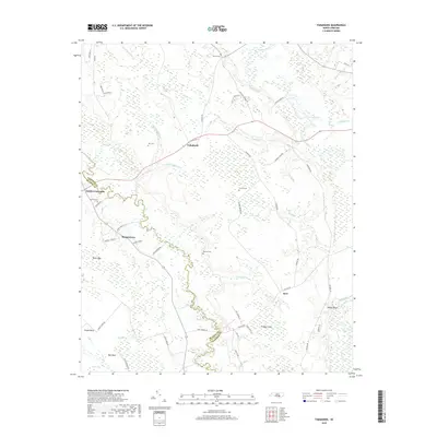
2019 Map of Tomahawk
USGS Topo · Published 2019About this map
Tomahawk and Murphytown anchor this rural landscape along the boundary of Sampson and Bladen counties, defined by the winding course of the Black River and the South River. The region is characterized by unique Carolina bay formations such as Dismal Bay, Eb Bay, and Kelso Bay, which influence the local drainage patterns and road networks. Smaller communities like Smith Crossroads and Kerr serve as local landmarks, while numerous family-named cemeteries including Herring Cem, Kerr Cem, and Sutton Cem provide valuable touchpoints for genealogical research. The river-driven geography is further detailed by features like Bloody Bluff and Pridgen Flats, while the presence of Enoch Mill Cr suggests the area's historical reliance on water power for local industry.
Find a feature on this map
66 named features on this map. Tap any name to fly to it.
Don’t see what you’re looking for? This feature index may not catch every label — zoom into the map to look around manually.
Map Details
Editions of this 2019 Tomahawk Map
This is the sole edition of this map. No revisions or reprints were ever made.
Other maps of this area

1953 · Florence
USGS Topo · 1:250,000

1954 · Florence
USGS Topo · 1:250,000

1954 · White Lake
USGS Topo · 1:62,500

1955 · Atkinson
USGS Topo · 1:62,500

1959 · Garland
USGS Topo · 1:62,500

1962 · Rose Hill
USGS Topo · 1:62,500

1982 · Elizabethtown
USGS Topo · 1:100,000
1984 · Harrells
USGS Topo · 1:24,000
1984 · Delway
USGS Topo · 1:24,000
1984 · Atkinson
USGS Topo · 1:24,000