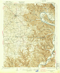
1929 Map of Tompkinsville
USGS Topo · Published 1939About this map
Tompkinsville serves as the focal point of this mid-1920s survey, anchoring a region of the Upper Cumberland defined by its sharp river bends and scattered rural communities. The Cumberland River carves a dramatic path through the landscape, most notably at Turkey Neck Bend, where the river's commerce is evidenced by numerous historical points like Geralds Landing and Pruitt Landing. This era precedes the major dam projects that would later alter these river valleys, showing the original course of the Obey River near Celina.
Find a feature on this map
115 named features on this map. Tap any name to fly to it.
Don’t see what you’re looking for? This feature index may not catch every label — zoom into the map to look around manually.
Map Details
Editions of this 1929 Tompkinsville Map
4 editions found
Other maps of this area

1897 · Standingstone
USGS Topo · 1:125,000

1898 · Standingstone
USGS Topo · 1:125,000

1924 · Lillydale
USGS Topo · 1:62,500

1925 · Gainesboro
USGS Topo · 1:62,500

1926 · Lillydale
USGS Topo · 1:62,500

1929 · Lillydale
USGS Topo · 1:62,500

1929 · Gainesboro
USGS Topo · 1:62,500

1929 · Tompkinsville
USGS Topo · 1:62,500

1931 · Red Boiling Springs
USGS Topo · 1:62,500

1932 · Carthage
USGS Topo · 1:62,500