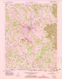
1954 Map of Tompkinsville
USGS Topo · Published 1983About this map
Tompkinsville serves as the central hub of this Monroe County landscape, where the Cordell Hull Highway intersects with a network of rural routes and creek-side settlements. The topography is defined by the winding course of the East Fork Barren River to the north and Mill Creek to the south. A significant historical anchor is the Old Mulkey Meeting House State Park, preserving a site of early pioneer worship. The map reveals a densely settled countryside during the mid-20th century, characterized by numerous small schoolhouses like Mt Zion Sch and Cave Spring Sch, and several rural churches including Athens Ch and Corinth Ch. Industrial and geological features also dot the terrain, from the Quarry near the town center to the subterranean Rhoton Cave in the south, reflecting a community closely tied to its limestone-rich environment.
Find a feature on this map
52 named features on this map. Tap any name to fly to it.
Don’t see what you’re looking for? This feature index may not catch every label — zoom into the map to look around manually.
Map Details
Editions of this 1954 Tompkinsville Map
3 editions found
Other maps of this area

1929 · Tompkinsville
USGS Topo · 1:62,500

1931 · Red Boiling Springs
USGS Topo · 1:62,500

1953 · Sulphur Lick
USGS Topo · 1:24,000

1953 · Freedom
USGS Topo · 1:24,000

1953 · Dubre
USGS Topo · 1:24,000

1954 · Gamaliel
USGS Topo · 1:24,000

1954 · Tompkinsville
USGS Topo · 1:24,000
1954 · Vernon
USGS Topo · 1:24,000

1956 · Corbin
USGS Topo · 1:250,000

1958 · Corbin
USGS Topo · 1:250,000