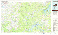
1985 Map of Tompkinsville
USGS Topo · Published 1986About this map
The Cumberland River and its massive impoundments dominate this mid-1980s look at the Kentucky-Tennessee borderlands. At the eastern edge, the Wolf Creek Dam holds back the expansive waters of Lake Cumberland, while further south, the fingers of Dale Hollow Lake State Park reach into the ridge-and-hollow terrain. The map captures a mix of established county seats like Glasgow and Edmonton alongside uniquely named rural crossroads such as Eighty Eight, Bugtussle, and Sulphur Lick. Cultural history is anchored by the Old Mulkey Meeting House State Park near Tompkinsville, representing one of the region's oldest religious landmarks. The landscape is defined by its drainage patterns, with the Barren River and Skaggs Creek carving through the western reaches, supporting a network of small settlements like Mount Hermon and Flippin connected by winding country roads and the Cumberland Parkway.
Find a feature on this map
210 named features on this map. Tap any name to fly to it.
Don’t see what you’re looking for? This feature index may not catch every label — zoom into the map to look around manually.
Map Details
Editions of this 1985 Tompkinsville Map
2 editions found
Other maps of this area

1895 · Wartburg
USGS Topo · 1:125,000

1896 · Wartburg
USGS Topo · 1:125,000

1897 · Standingstone
USGS Topo · 1:125,000

1898 · Standingstone
USGS Topo · 1:125,000

1911 · Monticello
USGS Topo · 1:62,500

1914 · Monticello
USGS Topo · 1:62,500

1922 · Mammoth Cave
USGS Topo · 1:62,500

1923 · Mammoth Cave
USGS Topo · 1:62,500

1924 · Lillydale
USGS Topo · 1:62,500

1925 · Gainesboro
USGS Topo · 1:62,500