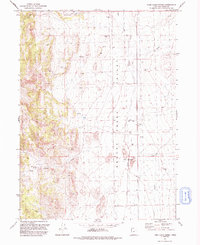
1991 Map of Toms Cabin Spring
USGS Topo · Published 1992About this map
Grouse Creek defines the low-lying valley center in this remote corner of Box Elder County, where water management is the primary driver of the landscape's layout. The map documents an extensive Aqueduct system and several wells that supported ranching operations in a region where reliable water was scarce. Significant drainage comes from the surrounding highlands via Dairy Valley Creek, Etna Creek, and Toms Cabin Creek, creating a network of seasonal flows that converge in the valley floor. Human activity is sparse and functional, marked by a lone Corral and a network of 4wd tracks that provide the only access through the basin and up toward the prominent rising terrain of The Buttes. This 1991 revision provides a detailed look at the infrastructure of high-desert ranching, from localized springs to engineered water transport.
Find a feature on this map
9 named features on this map. Tap any name to fly to it.
Don’t see what you’re looking for? This feature index may not catch every label — zoom into the map to look around manually.
Map Details
Editions of this 1991 Toms Cabin Spring Map
This is the sole edition of this map. No revisions or reprints were ever made.
Other maps of this area

1954 · Brigham City
USGS Topo · 1:250,000

1955 · Wells
USGS Topo · 1:250,000

1958 · Wells
USGS Topo · 1:250,000

1958 · Brigham City
USGS Topo · 1:250,000

1961 · Wells
USGS Topo · 1:250,000

1961 · Dairy Valley
USGS Topo · 1:62,500

1962 · Brigham City
USGS Topo · 1:250,000

1967 · Jackson Spring
USGS Topo · 1:24,000
1967 · Lucin NW
USGS Topo · 1:24,000

1967 · Lucin NE
USGS Topo · 1:24,000