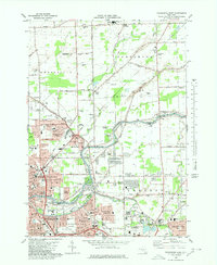
1980 Map of Tonawanda East
USGS Topo · Published 1980About this map
North Tonawanda and its surrounding suburbs in Wheatfield, Pendleton, and Amherst are captured here during a period of significant suburban expansion. The historic Erie Canal flows through the center of the sheet, doubling as Tonawanda Creek to separate Niagara and Erie counties. The landscape transitions from the dense urban grid of Tonawanda and neighborhoods like Martinsville and Wurlitzer Park Village into the developing residential tracts of Willow Ridge Estates and North Forest Acres. Large institutional and memorial spaces are prominent, including the White Chapel Memorial Cem and Acacia Park Cemetery, alongside the U S Military Reservation in the north. This 1980 update documents the region just as the Youngmann Expressway and established Conrail lines facilitated the growth of centers like Getzville and the Brighton area.
Find a feature on this map
82 named features on this map. Tap any name to fly to it.
Don’t see what you’re looking for? This feature index may not catch every label — zoom into the map to look around manually.
Map Details
Editions of this 1980 Tonawanda East Map
This is the sole edition of this map. No revisions or reprints were ever made.
Other maps of this area

1894 · Buffalo
USGS Topo · 1:62,500

1897 · Tonawanda
USGS Topo · 1:62,500

1897 · Lockport
USGS Topo · 1:62,500

1899 · Niagara
USGS Topo · 1:125,000

1900 · Tonawanda
USGS Topo · 1:62,500

1901 · Buffalo
USGS Topo · 1:62,500

1901 · Tonawanda
USGS Topo · 1:62,500

1902 · Lockport
USGS Topo · 1:62,500

1905 · Depew
USGS Topo · 1:62,500

1905 · Lockport
USGS Topo · 1:62,500