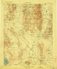
1908 Map of Tonopah
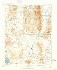
USGS Topo · Published 1922About this map
Tonopah stands as the primary hub of activity in this turn-of-the-century desert landscape, surrounded by high-altitude mining districts and the wide expanses of Big Smoky Valley. This 1908 edition records a transition period for Central Nevada, showing established centers like Belmont and Manhattan alongside newer gold-mining camps. The Goldfield R R connects these remote outposts, while old stage routes lead toward Antonio Sta and Midway Station.
Find a feature on this map
131 named features on this map. Tap any name to fly to it.
Don’t see what you’re looking for? This feature index may not catch every label — zoom into the map to look around manually.
Map Details
Editions of this 1908 Tonopah Map
3 editions found
Other maps of this area

1898 · Silver Peak
USGS Topo · 1:125,000

1900 · Silver Peak
USGS Topo · 1:125,000

1907 · Tonopah
USGS Topo · 1:250,000

1908 · Kawich
USGS Topo · 1:250,000

1908 · Lida
USGS Topo · 1:250,000

1908 · Tonopah
USGS Topo · 1:250,000

1908 · Carson Sink
USGS Topo · 1:250,000

1909 · Hawthorne
USGS Topo · 1:250,000

1910 · Carson Sink
USGS Topo · 1:250,000

1911 · Hawthorne
USGS Topo · 1:250,000