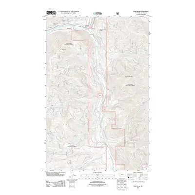
2011 Map of Tony Peak
USGS Topo · Published 2011About this map
The Kootenai River and Fisher River converge in this corner of Lincoln County, defining a landscape shaped by water and timber. The small settlement of Jennings sits along the Kootenai, while the David Thompson Bridge provides a vital crossing point near Big Bend. This 2011 survey documents the extensive Forest Service road network that threads through the peaks, including Canoe Gulch RD and various NFD routes serving the high country. High-elevation vantage points like the Tony Peak Lookout and Riverview Mountain oversee a terrain carved by numerous drainages such as Peoples Creek, Butler Creek, and Alder Creek. The presence of recreation-oriented sites like Sportsmans RV Park and Big Bend RV Park near the riverbanks highlights the modern transition of these river flats from early industrial use to seasonal destinations. Notable terrain features like Blackwell Flats and Big Bend Flats offer glimpses into the geographic character of this river-valley junction.
Find a feature on this map
31 named features on this map. Tap any name to fly to it.
Don’t see what you’re looking for? This feature index may not catch every label — zoom into the map to look around manually.
Map Details
Editions of this 2011 Tony Peak Map
This is the sole edition of this map. No revisions or reprints were ever made.
Other maps of this area

1920 · Jennings
USGS Topo · 1:125,000

1935 · Thompson Lakes
USGS Topo · 1:96,000

1942 · Thompson Lakes
USGS Topo · 1:125,000

1957 · Kalispell
USGS Topo · 1:250,000

1960 · Kalispell
USGS Topo · 1:250,000

1961 · Kalispell
USGS Topo · 1:250,000

1963 · Vermiculite Mountain
USGS Topo · 1:24,000

1963 · Swede Mountain
USGS Topo · 1:24,000

1963 · Cripple Horse Mountain
USGS Topo · 1:24,000
1963 · Tony Peak
USGS Topo · 1:24,000