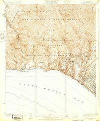
1928 Map of Topanga Canyon
USGS Topo · Published 1932About this map
The Santa Monica Mountains meet the sea in this early 20th-century survey, revealing a landscape of coastal development and private estates before the heavy urbanization of later decades. Early communities like Castellammare and Inceville sit perched above the Coast Highway, while specialized land uses are evident at the Uplifters Ranch, Trippet Ranch, and Claude Parker Ranch. The rugged canyon geography is clearly defined by drainage systems such as Temescal Canyon and Rustic Canyon, which channel toward the Santa Monica Bay. Along the shoreline, landmarks like Castle Rock and the Natural Arch provide a look at the geological features that defined the coastline prior to extensive modern infrastructure. The emergence of the Pacific Palisades and the organized Assembly Camp highlight the area's early growth as a destination for both residential retreat and seasonal gathering.
Find a feature on this map
34 named features on this map. Tap any name to fly to it.
Don’t see what you’re looking for? This feature index may not catch every label — zoom into the map to look around manually.
Map Details
Editions of this 1928 Topanga Canyon Map
3 editions found
Other maps of this area

1894 · Los Angeles
USGS Topo · 1:62,500

1896 · Redondo
USGS Topo · 1:62,500

1896 · Santa Monica
USGS Topo · 1:62,500

1898 · Santa Monica
USGS Topo · 1:62,500

1900 · Los Angeles
USGS Topo · 1:62,500

1901 · Southern California Sheet No. 1
USGS Topo · 1:250,000

1902 · Santa Monica
USGS Topo · 1:62,500

1903 · Calabasas
USGS Topo · 1:62,500

1903 · Camulos
USGS Topo · 1:125,000

1904 · Southern California Sheet No. 1
USGS Topo · 1:250,000