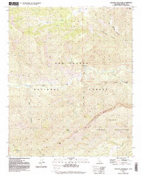
1991 Map of Topatopa Mountains
USGS Topo · Published 1991About this map
Topatopa Mountains rise above a landscape defined by deep drainages and protected wilderness in this 1991 survey of Ventura County. The map details the central portion of the Los Padres National Forest, including the Sespe Condor Sanctuary, which is delineated by the Condor Sanctuary Boundary. This area is characterized by the complex hydrology of Sespe Creek and its many tributaries, such as Sycamore Creek and Timber Creek. Small mountain clearings like Oak Flat and the remote Willet Hot Springs suggest the specialized recreation and seasonal occupancy typical of this high-elevation terrain. Prominent summits, including Hines Peak and San Rafael Peak, anchor the topographical record, while family-named features like Johnston Ridge and Santa Paula Canyon provide essential points of reference for local historians and backcountry travelers.
Find a feature on this map
22 named features on this map. Tap any name to fly to it.
Don’t see what you’re looking for? This feature index may not catch every label — zoom into the map to look around manually.
Map Details
Editions of this 1991 Topatopa Mountains Map
2 editions found
Other maps of this area

1900 · Piru
USGS Topo · 1:62,500

1903 · Santa Paula
USGS Topo · 1:62,500

1903 · Mt. Pinos
USGS Topo · 1:125,000

1903 · Tejon
USGS Topo · 1:125,000

1903 · Camulos
USGS Topo · 1:125,000

1921 · Piru
USGS Topo · 1:62,500

1941 · Piru
USGS Topo · 1:62,500

1942 · Santa Paula
USGS Topo · 1:62,500

1943 · Topatopa Mountains
USGS Topo · 1:24,000

1943 · San Guillermo
USGS Topo · 1:24,000