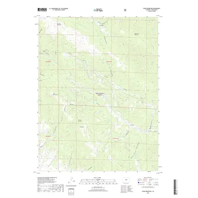
2019 Map of Topaz Mountain
USGS Topo · Published 2019About this map
Topaz Mountain and North Tarryall Peak dominate this high-altitude landscape in the heart of the Pike National Forest. This 2019 survey captures the confluence of several major ranges, where the Kenosha Mountains, Platte River Mountains, and Tarryall Mountains converge in a complex of ridgelines and high basins. The drainage patterns here are particularly intricate, with waters flowing through systems like N Fork Lost Creek and S Fork Lost Creek towards the open area of Lost Park. Named gulches such as Derbyshire Gulch and Potato Gulch suggest a history of prospecting or early ranching, while isolated features like Bonis Spring and the Wigwam landmark provide specific points of interest for those tracking local geographical history and historical land use within the forest boundaries.
Find a feature on this map
40 named features on this map. Tap any name to fly to it.
Don’t see what you’re looking for? This feature index may not catch every label — zoom into the map to look around manually.
Map Details
Editions of this 2019 Topaz Mountain Map
This is the sole edition of this map. No revisions or reprints were ever made.
Other maps of this area

1893 · Platte Canyon
USGS Topo · 1:125,000

1945 · Bailey
USGS Topo · 1:24,000

1945 · Shawnee
USGS Topo · 1:24,000

1945 · Mount Logan
USGS Topo · 1:24,000

1948 · Mount Logan
USGS Topo · 1:24,000

1948 · Shawnee
USGS Topo · 1:24,000

1949 · Bailey
USGS Topo · 1:24,000

1953 · Denver
USGS Topo · 1:250,000
1954 · Windy Peak
USGS Topo · 1:24,000

1956 · Eagle Rock
USGS Topo · 1:24,000