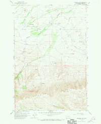
1958 Map of Toppenish Mtn.
USGS Topo · Published 1970About this map
The Yakima Indian Christian Mission stands as a focal point of this late-1950s landscape, situated at the intersection of Mission Road and Fort Simcoe Road. This terrain is defined by the sharp transition from the irrigated agricultural lands of the north to the rising elevations of Toppenish Ridge. Water management is central to the area's development, evidenced by the complex network of the Shaker Canal, Unit 2 Canal, and numerous siphons designed to navigate the uneven topography.
Find a feature on this map
27 named features on this map. Tap any name to fly to it.
Don’t see what you’re looking for? This feature index may not catch every label — zoom into the map to look around manually.
Map Details
Editions of this 1958 Toppenish Mtn. Map
2 editions found
Other maps of this area

1937 · White Swan
USGS Topo · 1:125,000

1950 · Yakima
USGS Topo · 1:250,000

1958 · Toppenish Mtn.
USGS Topo · 1:24,000

1958 · Harrah
USGS Topo · 1:24,000

1958 · Fort Simcoe
USGS Topo · 1:24,000

1958 · Fort Simcoe
USGS Topo · 1:62,500

1958 · White Swan
USGS Topo · 1:24,000
1958 · Medicine Valley
USGS Topo · 1:24,000

1958 · Harrah SE
USGS Topo · 1:24,000

1958 · Yakima
USGS Topo · 1:250,000