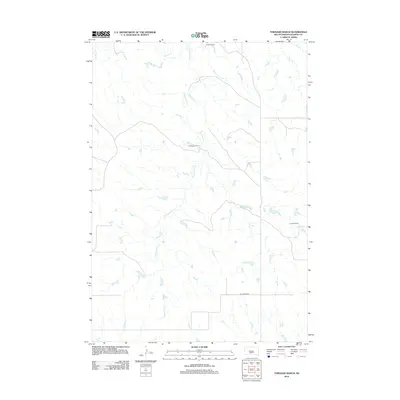
2012 Map of Tornado Ranch
USGS Topo · Published 2012About this map
Tornado Ranch serves as a central landmark in this portion of Haakon County, where the landscape is defined by the drainage systems of Cottonwood Cr and W Plum Cr. This 2012 survey documents a sparsely populated ranching region of South Dakota, illustrating the vast spacing between established family holdings. Named locations such as Noteboom Ranch, O Neill Ranch, and Hansen Ranch highlight the enduring importance of individual cattle operations in the local economy and social structure. The distribution of these ranches relative to the winding creek beds suggests a reliance on natural water sources and the topography of the plains. This map provides a detailed view of the rural infrastructure and land use patterns that characterize this Western river basin region at the start of the 2010s.
Find a feature on this map
6 named features on this map. Tap any name to fly to it.
Don’t see what you’re looking for? This feature index may not catch every label — zoom into the map to look around manually.
Map Details
Editions of this 2012 Tornado Ranch Map
This is the sole edition of this map. No revisions or reprints were ever made.
Other maps of this area

1954 · Pierre
USGS Topo · 1:250,000

1958 · Pierre
USGS Topo · 1:250,000

1983 · Mule Creek
USGS Topo · 1:24,000

1983 · Philip
USGS Topo · 1:100,000
1983 · Elevenmile Corner
USGS Topo · 1:24,000

1983 · Milesville
USGS Topo · 1:24,000

1983 · Middle Draw
USGS Topo · 1:24,000

1983 · Powell NW
USGS Topo · 1:24,000

1983 · Tornado Ranch
USGS Topo · 1:24,000
1983 · Lucerne
USGS Topo · 1:24,000