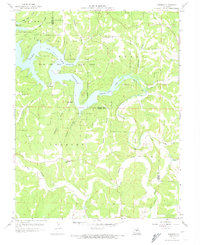
1959 Map of Toronto
USGS Topo · Published 1974About this map
Lake of the Ozarks State Park dominates the northern half of this mid-century Missouri landscape, where the irregular shoreline of the Grandglaize Arm carves deep into the hills. This 1959 revision reflects a region shaped by both recreational development and long-standing rural community structures. The settlement of Toronto sits near the southern edge, while smaller locales like Passover and Low Gap appear closer to the winding waters. Deeply dissected terrain is punctuated by significant local landmarks, including the Kaiser Lookout Tower and Ozark Caverns. For genealogists and local historians, the sheet preserves the locations of essential community centers like Freedom Sch and New Hope Ch, alongside rural burial grounds such as Auglaize Cem and Popplewell Cem. The convergence of Auglaize Creek and Wet Glaize Creek highlights the complex drainage patterns that defined transportation and settlement before the reservoir changed the character of these valleys.
Find a feature on this map
28 named features on this map. Tap any name to fly to it.
Don’t see what you’re looking for? This feature index may not catch every label — zoom into the map to look around manually.
Map Details
Editions of this 1959 Toronto Map
3 editions found
Other maps of this area

1888 · Versailles
USGS Topo · 1:125,000

1888 · Tuscumbia
USGS Topo · 1:125,000

1893 · Versailles
USGS Topo · 1:125,000

1894 · Tuscumbia
USGS Topo · 1:125,000

1932 · Versailles No 4
USGS Topo · 1:48,000

1933 · Stoutland
USGS Topo · 1:62,500

1933 · Iberia
USGS Topo · 1:62,500

1934 · Camdenton
USGS Topo · 1:24,000

1934 · Toronto
USGS Topo · 1:24,000

1934 · Lake Ozark
USGS Topo · 1:24,000