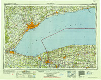
1952 Map of Toronto
USGS Topo · Published 1954About this map
Lake Ontario serves as the central focal point of this mid-century international survey, documenting the dense industrial and urban development along the "Golden Horseshoe" of Ontario and the agricultural landscapes of Western New York. The map captures a significant period of infrastructure growth, featuring the established Welland Canal and the emerging New York State Thruway. Major urban centers like Toronto and Hamilton are shown at a peak of post-war expansion, with the extensive Canadian National Railways network connecting them to outlying towns such as Brampton and Oshawa. On the American shore, the Niagara River separates Niagara Falls from its Canadian counterpart, while the Erie Canal continues its path through Lockport and Medina. The topographic detail highlights prominent natural landmarks including the Niagara Escarpment and the Scarborough Bluffs, alongside strategic sites like Fort Niagara.
Find a feature on this map
142 named features on this map. Tap any name to fly to it.
Don’t see what you’re looking for? This feature index may not catch every label — zoom into the map to look around manually.
Map Details
Editions of this 1952 Toronto Map
This is the sole edition of this map. No revisions or reprints were ever made.
Other maps of this area

1894 · Buffalo
USGS Topo · 1:62,500

1894 · Niagara Falls
USGS Topo · 1:62,500

1894 · Wilson
USGS Topo · 1:62,500

1896 · Niagara Falls
USGS Topo · 1:62,500

1897 · Tonawanda
USGS Topo · 1:62,500

1897 · Albion
USGS Topo · 1:62,500

1897 · Olcott
USGS Topo · 1:62,500

1897 · Medina
USGS Topo · 1:62,500

1897 · Lockport
USGS Topo · 1:62,500

1897 · Oak Orchard
USGS Topo · 1:62,500